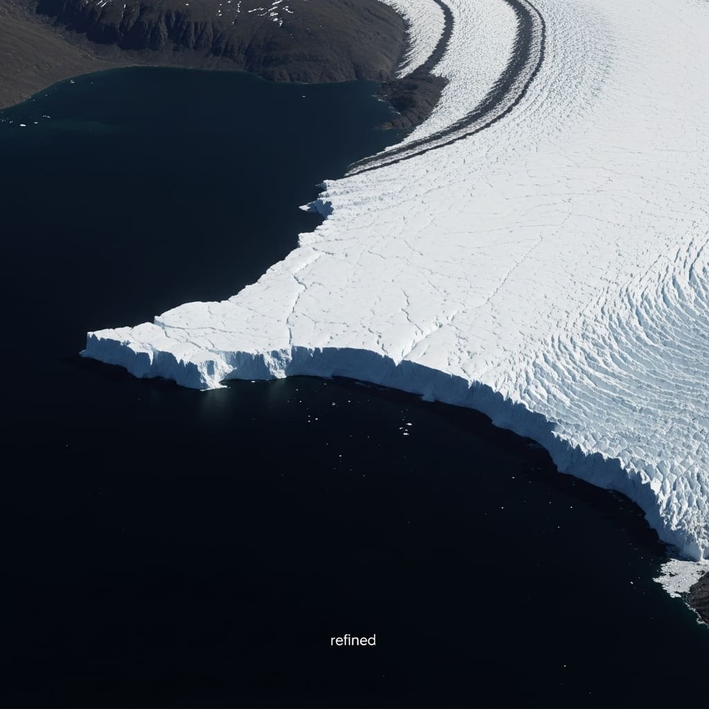
Scientists are tackling the important challenge of precisely mapping glacier collapse fronts, a key indicator of ice loss and sea level rise. Marcel Dreier, Nora Gourmeron, and Dakota Pyles from the Institute for Pattern Recognition and Geography at the Friedrich-Alexander-University Erlangen-Nuremberg, along with Seehaus and colleagues, are demonstrating significant progress in this field. Their work addresses the common problem of machine learning models failing when deployed to new locations and shows how incorporating temporal references and static spatial information can dramatically improve performance. By reducing depiction error over 1100 meters to just 68.7 meters without changing the core model, this study establishes a robust framework for monitoring the global glacier melt front, unlocking more reliable data for climate change research.
Their work addresses the common problem of machine learning models failing when deployed to new locations and shows how incorporating temporal references and static spatial information can dramatically improve performance.
Domain adaptation improves mapping of glacier melt fronts
Scientists have made significant progress in monitoring glacier melt fronts, overcoming limitations in applying existing deep learning models to new geographic locations. This advancement solves the challenge of transferring models trained on benchmark datasets to real-world scenarios, with a particular focus on Svalbard, an outlying region. This minimizes the need for extensive and time-consuming manual annotation of new survey sites. Additionally, the researchers incorporated spatial static prior knowledge through the use of rock masks, providing important contextual information about local glacier shape.
These masks help differentiate difficult features such as rocks, glacier ice, and ice melanges, which are mixtures of sea ice and icebergs that often confuse segmentation algorithms. The key innovation lies in the inclusion of a summer reference image within the input time series. Integrating images captured during periods when ice melange is minimal significantly improves model performance, especially in scenes that are highly affected by this phenomenon. Tyrion-T-GRU, the state-of-the-art model used in this work, processes time-series synthetic aperture radar (SAR) acquisitions to produce semantic segmentation maps that identify glaciers, oceans, rocks, and areas for which no information is available. Calving fronts are derived from these segmentation maps, and sophisticated methodologies greatly improve the accuracy of this process. Experimental results reveal that our approach, combined with few-shot adaptation, static priors, and temporal references, effectively mitigates the domain shift between the benchmark data and the Svalbard environment.
Svalbard domain adaptation for calving front delineation
Scientists addressed limitations in applying state-of-the-art glacier melt front delineation models to new environments by pioneering a domain adaptation strategy focused on Svalbard. Initial testing reveals that Tyrion-T-GRU, a model that achieves near-human performance on the CaFFe benchmark dataset, results in a significant delineation error of 1131.6m when deployed at this new research site. The researchers recognized that this inaccuracy was due to out-of-distribution areas and that methodological improvements were needed to facilitate accurate monitoring of the calving front. To alleviate this, this study compiled a new Svalbard dataset containing one manual annotation per glacier, supplemented with existing CaFFe data for additional training.
We adopted a temporal approach in our experiments, leveraging data from three years ago in the training set to rigorously evaluate performance. The team innovated by constructing a time series consisting of a composite of annual images, rather than strictly sequential acquisitions, and strategically incorporating summer reference images. This technique aims to reduce the ambiguity caused by ice melanges. This is a difficult feature, especially when dominating the scene, due to backscattering properties similar to glacier ice. Tyrion-T-GRU already shares information across eight image series, but this improvement further enhances its ability to identify glacier features.
Furthermore, the scientists leveraged spatial static prior knowledge by integrating rock masks as an additional input modality. This mask representing stable rock locations provides important contextual information about the local glacier shape and helps identify rocks, glacier ice, and ice melanges during the segmentation process. The system provides semantic segmentation for each acquisition, classifying regions into glaciers, oceans, rocks, or regions where no information is available.
Domain adaptation reduces front depiction error by half
Scientists have succeeded in significantly reducing front delineation errors through a new domain adaptation strategy. Initial tests using the state-of-the-art Tyrion-T-GRU model on Svalbard showed a delineation error of 1131.6m, insufficient for precise scientific analysis. The researchers addressed this limitation by incorporating spatial prior knowledge and a summer reference image into the input time series, and were able to reduce the error to 68.7m without changing the model architecture. The study used synthetic aperture radar (SAR) for year-round observations and focused on the calving front, a critical boundary between glaciers and the ocean.
Although near-human performance was achieved on the “CAlving Fronts and where to Find thEm” (CaFFe) benchmark dataset, transferring these results to real-world scenarios revealed limitations when encountering data from new sensors and previously unrepresented research sites. Specifically, Svalbard exhibited an out-of-distribution area with different geometry, surface conditions, and climatic influences from glaciers in the benchmark dataset. To overcome this, the team compiled a new dataset containing one manual annotation for each glacier in Svalbard, complementing the existing CaFFe data for training purposes. Experiments demonstrated that even one label per glacier provides sufficient guidance for domain adaptation, in contrast to approaches that utilize multiple images.
The main challenge identified is the ice melange, which is a mixture of sea ice and icebergs, exhibiting backscatter properties similar to glacier ice and causing segmentation ambiguity. Tyrion-T-GRU alleviated this problem by sharing information across a time series of eight images, but it left a persistent error when an ice melange dominated the scene. To further improve performance, the researchers introduced an inference strategy that leveraged summer acquisitions, when ice melanges are typically absent, to create an annual composite time series. Additionally, incorporating a static rock mask as an additional input modality provided important spatial prior information. The positions of these rocks were stable over time and helped distinguish between rocks, glacier ice, and ice melanges during the segmentation process.
Domain adaptation improves depiction of glacier melt due to migration
Scientists have demonstrated that a state-of-the-art model for describing glacier collapse fronts performs well in benchmark tests but is insufficiently accurate when applied to a new, never-before-seen research site. This limitation occurs because the model was trained only on the benchmark dataset representing the out-of-distribution domain of new locations. These methodological advances significantly reduced the delineation error from 1131.6m to 68.7m without making any changes to the underlying architecture of the model. The authors acknowledge that the current study is limited to S1 images of Svalbard and further evaluation using other regions and sensors is required. Future research could benefit from continuous learning approaches that allow models to gradually absorb new data and adapt to changing conditions without complete retraining.
👉 More information
🗞 Few-shot domain adaptation using temporal references and static priors for glacier melt front delineation
🧠ArXiv: https://arxiv.org/abs/2601.21663