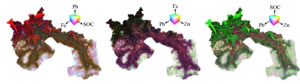
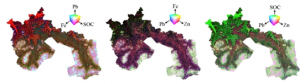
Visualization of soil associates of lead: trivariate maps of Pb, Zn, Fe, and SOC.
FAYETTEVILLE, Ga., May 26, 2026 /EINPresswire.com/ — Lead (Pb) contamination in agricultural soils is an invisible threat that can enter the food system and endanger public health. To address this risk, scientists have developed a powerful new method to map and predict soil Pb levels by combining machine learning algorithms with spectral imaging and topographic data. Among several tested models, the extreme gradient boosting (EGB) algorithm combined with specially preprocessed spectral data and terrain features achieved the highest prediction accuracy. This integrated approach not only pinpoints contamination hotspots, but also provides a fast, non-invasive tool to monitor soil quality and inform land use decisions.
Lead (Pb), a persistent toxic element in soil, often comes from industrial activities, vehicle exhaust, and agricultural inputs. Their presence on agricultural land can cause serious health risks, especially for children, and poses food safety challenges. Traditional soil analysis methods are costly and labor intensive, making large-scale monitoring impractical. In contrast, remote sensing techniques, particularly those using the visible and infrared spectra, offer a rapid alternative, but without advanced processing spectral data alone can be noisy and unreliable. These limitations have increased the need to develop accurate, scalable, data-driven approaches to detect and manage lead contamination in soil.
In a study published in Pedosphere on March 26, 2025 (DOI: 10.1016/j.pedsph.2024.01.002), researchers from the Czech University of Life Sciences in Prague, together with international collaborators, presented a new soil contamination prediction framework. By fusing spectral data, topographic variables, and six advanced machine learning models, the research team was able to predict the distribution of Pb in agricultural soils. This study not only improves the accuracy of contamination mapping, but also reveals the environmental factors most responsible for the spread of lead.
The researchers collected 115 topsoil samples across farmland in the Czech Republic and measured lead concentrations, along with iron, zinc, and soil organic carbon (SOC). A high-resolution spectrometer was used to acquire VNIR-SWIR spectral data, which was combined with six key terrain attributes including slope, elevation, and drainage pattern. These datasets were input into six machine learning algorithms, including artificial neural networks (ANN), support vector machines (SVM), and extreme gradient boosting (EGB). After extensive model testing, the combination of the EGB algorithm and standard normal variate (SNV) treated spectral and topographic features resulted in the most accurate predictions with an R² 0.75 and a low error margin. This study also used trivariate mapping to visualize the spatial relationships of lead with SOC and iron, revealing that elevation and slope are the main drivers of lead distribution. These insights highlight the power of combining environmental sensing and AI to unravel complex pollution dynamics in soil ecosystems.
“Our results show that artificial intelligence has the potential to revolutionize how soil pollution is detected and managed,” said the study’s lead author, Dr. Prince Chapman-Agyeman. “By integrating machine learning with spectral and topographic data, we have built a reliable and cost-effective system for predicting lead contamination. This approach gives land managers and environmental authorities the tools they need to act quickly and efficiently before contamination becomes a crisis.”
This innovative approach paves the way for real-time, scalable soil monitoring systems. It helps farmers and policymakers identify contamination hotspots, prioritize remediation, and ensure food safety. This framework can be adapted to detect other contaminants such as cadmium and arsenic, and can also be enhanced with additional data such as land use, climate, and crop history. Future studies may integrate deep learning, mid-infrared spectroscopy, or portable X-ray fluorescence (PXRF) to improve prediction depth and resolution. Ultimately, this convergence of AI and environmental sensing offers a promising path toward cleaner soils and safer agriculture in a changing world.
References
Toi
10.1016/j.pedsph.2024.01.002
Original source URL
https://doi.org/10.1016/j.pedsph.2024.01.002
Funding information
This research was supported by the institutional Ph.D. Grant (No. 21130/1312/3131) from the Department of Agricultural Biology, Food and Natural Resources of the Czech University of Life Sciences Prague (CZU), Czech Republic.
Lucy Wang
biodesign research
please email here
Legal disclaimer:
EIN Presswire provides this news content “as is” without warranty of any kind. Our company does not assume any responsibility or liability
The accuracy, content, images, videos, licenses, completeness, legality, or reliability of the information contained herein;
article. If you have any complaints or copyright issues related to this article, kindly contact the author above.