
The US is reportedly bringing powerful new weapons to the Iran war. It’s a large artificial intelligence (AI) model tasked with automating every step of the targeting process, from analyzing satellite images to choosing the final attack.
However, how these systems operate remains a closely guarded secret, and incidents such as the February elementary school bombing in southern Iran that killed more than 200 children have heightened public concerns about AI’s potential role in war crimes.
Now, China has taken the first step towards transparency.
Last month, Chinese aerospace researchers announced the Air Target Agent System, a powerful LLM agent collaboration AI tool designed to take satellite surveillance beyond image recognition, allowing satellites to analyze what they see, draw conclusions, and autonomously act on them.
In the future, we will further explore deployment and optimization strategies in large-scale real-world application scenarios.
Wang Lei, Chinese Academy of Sciences
The system combines large-scale language models (LLMs) and AI agents that can decompose complex tasks, automatically select algorithms, adjust workflows, and recover from failures without human intervention.
Satellite data can be fused with information collected by drones, surveillance cameras, or humans on the ground to reduce errors in target screening.
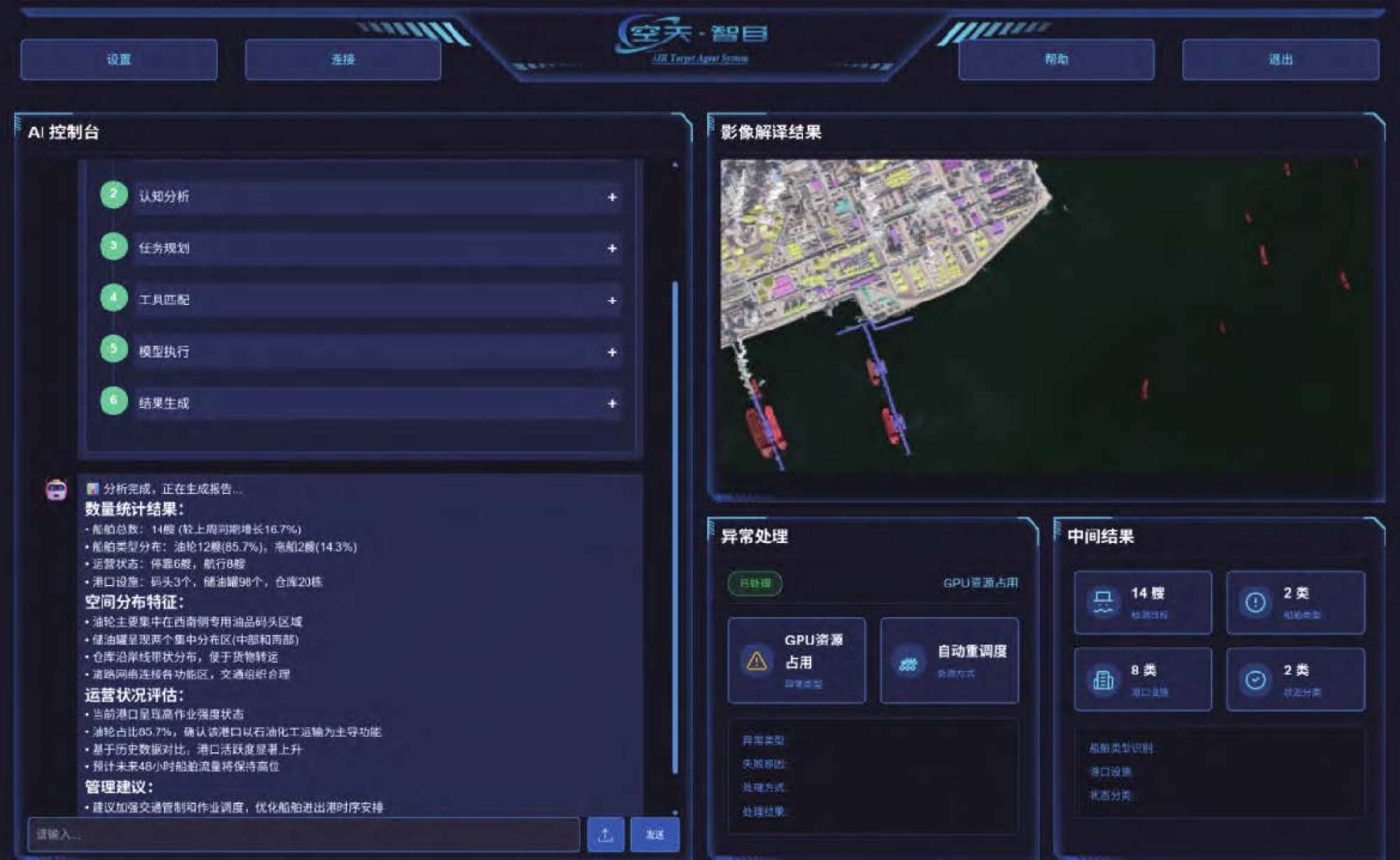
Researchers say the system has already been tested in port surveillance scenarios, where it autonomously analyzes vessel activity and operational status. According to the researchers, the system reduced the time required to complete an analysis from 342 seconds to 198 seconds and increased GPU (graphics processing unit) utilization by 148.4%.
The study was published in the peer-reviewed Journal of the Chinese University of Astronautics and Astronautics by researchers from the Institute of Aerospace Information, Chinese Academy of Sciences and its principal institutes.
The University of Space Engineering is operated by the People’s Liberation Army Aerospace Command.

“Compared to traditional methods, [the system offers] It has good practicality, stability, and scalability in terms of execution efficiency, abnormality recovery, resource utilization, and tool integration efficiency,” principal investigator Wang Lei and his colleagues wrote.
This study describes this transition as a transition from traditional “data algorithm-driven” systems to “cognition-driven” remote sensing.
This research reflects a broader global race to apply generative AI to Earth observation. Organizations in the United States and Europe are pursuing similar technologies through projects such as Google Earth AI, NASA’s Earth Science Data Systems Program, and the European Space Agency’s AI-based Models Initiative. Academic projects such as EarthGPT and GeoChat are also exploring the use of large-scale AI models for remote sensing interpretation.
China may hold several advantages in this emerging field, including vast domestic data volumes, a rapidly growing commercial space industry, and strong state support for the integration of AI and aerospace infrastructure.
China’s system is built around an architecture that researchers describe as an “army of AI brains and tools.” LLM acts as a cognitive center responsible for understanding requests, planning workflows, and allocating computing resources, while AI agents execute tasks, use specialized tools, and automatically coordinate subtasks.
“The next generation of intelligent and scalable remote sensing information processing systems has laid a solid technological foundation,” Wang wrote.
One of the platform’s breakthrough features is automatic task decomposition. When a user issues a command, such as analyzing port operations, the system separates the request into vessel detection, vessel classification, dock analysis, and traffic prediction tasks, and then organizes it into an optimized workflow.
Unlike traditional serial processing systems, AI platforms can perform multiple subtasks in parallel while sharing intermediate results to avoid redundant computations. The study showed that CPU (central processing unit) utilization increased from 34.2 percent to 67.8 percent and task success rate increased from 70 percent to 90 percent.
The system also demonstrated autonomous disaster recovery. During one port monitoring experiment, the target recognition model failed because GPU resources were already in use. The platform automatically diagnosed the problem and switched to an alternative model without human intervention.
“In the future, we will further explore optimizing the collaborative LLM agent mechanism in more complex scenarios, enhancing multimodal data fusion processing capabilities, and deploying and optimization strategies in large-scale real-world application scenarios,” Wang said.
He added that the goal is to develop an intelligent system for interpreting remote sensing targets that can operate autonomously and apply its capabilities to new situations. — South China Morning Post


