Newswise — Methane is the second most important anthropogenic greenhouse gas after carbon dioxide, with a global warming potential of approximately 28 to 34 times greater over a 100-year timescale. Major sources include fossil fuel production, agriculture, livestock, and landfill waste. In recent years, hyperspectral satellite remote sensing has become an important means of detecting methane emissions, as it can identify methane absorption signatures and reveal plume structures from orbit. However, converting these observations into reliable emissions estimates remains a major challenge. Widely used approaches, such as the integrated mass enhancement (IME) method, rely on simplifying assumptions about the relationship between plume mass and wind speed. In practice, these assumptions often fail to capture the complex interactions between atmospheric transport and plume shape, leading to large uncertainties in methane flux estimates.
To address this limitation, researchers from East China Normal University and collaborating institutions recently reported a new methane monitoring framework called CH4Vision (DOI: 10.34133/remotesensing.1013). Jremote sensing magazine (Published February 27, 2026). CH4Vision uses hyperspectral observations from the GaoFen-5 satellite to estimate methane emission fluxes by analyzing both plume morphology and concentration distribution. This framework aims to improve the reliability of satellite-based methane quantification by using machine learning to infer emission rates from a richer set of plume characteristics, rather than relying on simple linear relationships.
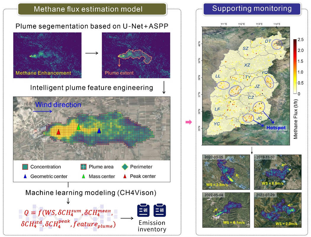
The central idea of CH4Vision is that methane plumes contain spatial information that reflects the intensity of the source. Rather than focusing primarily on plume area and wind speed like traditional IME-based methods, this framework extracts a broad set of descriptors that characterize plume shape and concentration structure. These include plume area, perimeter, aspect ratio, slope-related features, and concentration statistics. CH4Vision then integrates these variables into a random forest regression model that allows capturing the nonlinear relationship between plume structure and emission intensity.
To build the framework, the researchers first generated a large-scale training dataset using atmospheric maelstrom simulations. These simulations generated thousands of methane plume scenarios under various emission rates, wind conditions, and turbulence conditions. The simulated plume was then embedded into a hyperspectral scene captured by GaoFen-5’s Advanced Hyperspectral Imager. Methane enhancement concentrations were obtained using an improved algorithm known as SSRMF. This algorithm reduces background noise and false positives by reconstructing a pixel-level reference spectrum and maintaining spatial continuity across the plume structure. From the resulting plume map, the team extracted morphological and concentration-based features and used them to train a random forest regression model containing 500 decision trees to directly estimate methane fluxes from plume properties and wind information.
They also achieved good results in the evaluation test. Compared to the IME method, CH4Vision increased the coefficient of determination (R2) by 3-9% and decreased the estimation error by 14-36.5%. It also showed high resilience to wind speed and methane recovery uncertainties. This is particularly important for operational monitoring under real observation conditions. These results suggest that quantification of methane fluxes from satellite images can be significantly improved by incorporating plume morphology into the estimation process.
This framework was further tested in both controlled and real-world settings. In a methane emission control experiment conducted in Arizona, CH4Vision predicted emission rates to within approximately ±100 kg per hour of the true value. Applying this method to satellite observations over China’s Shanxi province, we detected hundreds of emitters, showing that traditional IME-based approaches significantly underestimated emissions from strong sources. These findings support the practical value of CH4Vision for identifying and quantifying methane emissions in complex real-world environments.
Overall, CH4Vision provides a powerful new tool for monitoring methane emissions from space. By improving the accuracy and robustness of satellite-based flux estimates, this framework could help researchers better limit global methane emissions and identify major emission hotspots. It could also support environmental regulation, climate policy, and energy sector oversight. Because the method emphasizes plume morphology rather than gas-specific assumptions, it could be applied in the future to other air pollutants that can be detected by hyperspectral satellites.
###
References
Toi
10.34133/Remote Sensing.1013
Original source URL
https://doi.org/10.34133/remotesensing.1013
Funding information
This research is supported by the National Natural Science Foundation of China (Grant No. 425B2007), the International Research Center for Big Data for Sustainable Development Goals (CBAS2022GSP07), and the Fundamental Research Funds of the Central Universities.
About remote sensing journal
of remote sensing journal, An online-only open access journal published in collaboration with AIR-CAS that promotes interdisciplinary research in the theory, science, and technology of remote sensing, as well as in the geosciences and information sciences.


