Soil quality is fundamental to sustainable agriculture, environmental health, and effective land management, but traditional assessment methods have proven costly and limit the scope of analysis. Habiba Ben Abderrahmane from Ammar Terizi University, Slimane Oulad-Naoui and Benameur Ziani from Ghardaia University, together with their colleagues, present a new roadmap for analyzing soil quality using modern geospatial techniques. This study sets itself apart from previous research by proposing an integrated system that combines diverse soil data with geographic information systems, remote sensing, and machine learning techniques. The team's approach provides a transparent and scalable method to assess soil quality, address current limitations, and pave the way for more adaptive and sustainable land management practices.
Digital soil mapping with machine learning
This extensive research reveals a rapidly evolving field focused on advanced soil mapping, monitoring, and management, making extensive use of geospatial techniques, data analysis, and machine learning. Beyond traditional soil surveys, scientists are integrating diverse data sources such as satellite imagery, aerial photography, field observations, and even microbiome data to create detailed soil maps and improve the accuracy of these maps. Machine learning algorithms play an important role in modeling soil properties and predicting soil degradation. Researchers are also investigating the effects of climate change on soil health, tracking changes in soil moisture, salinization, and land cover, and understanding land use changes to assess how human activities affect soil resources.
This study recognizes the challenges of storing, processing, and analyzing growing soil data and highlights the importance of big data and geoprocessing. Combining data from a variety of sources, remote sensing, field observations, and climate data is essential for a wide range of soil assessments, from precision agriculture and water management to erosion control and understanding the critical role of soil microbiota. Scientists are developing climate-smart agricultural practices that are resilient to climate change and contribute to carbon sequestration, demonstrating the global applicability of these technologies in regions facing data scarcity, limited resources, and severe soil degradation.
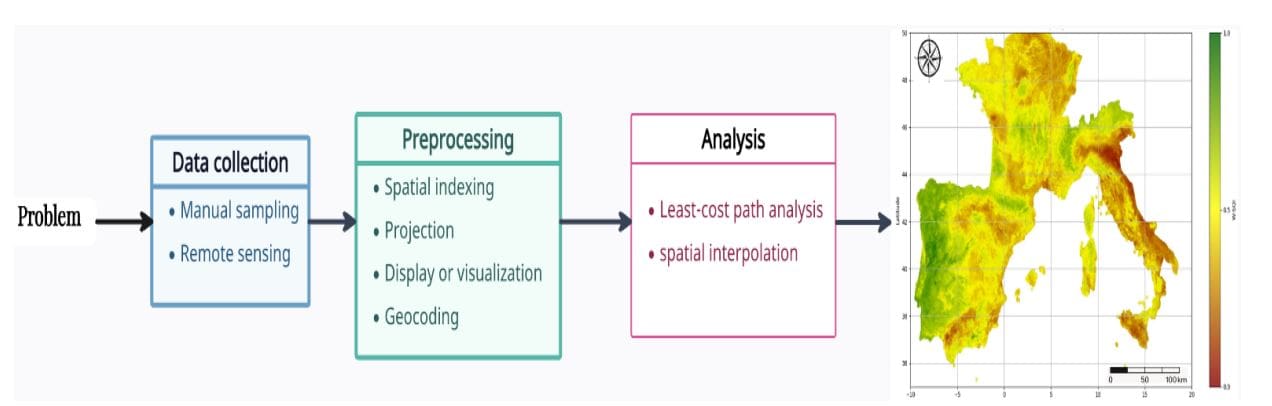
An integrated pipeline for scalable soil quality assessment
Scientists have developed a comprehensive roadmap for assessing soil quality, going beyond labor-intensive traditional methods. This effort pioneers an integrated, modular pipeline that integrates diverse data sources with geographic information systems and machine learning techniques to enable transparent and scalable soil quality assessments. The research team integrated recent advances in geospatial technology, remote sensing, and machine learning algorithms within a single framework to define key soil properties and metrics, integrating physical, chemical, and biological properties to accurately reflect soils' ability to perform important ecological functions. This study focuses on a comprehensive understanding of soil quality, going beyond single-factor analysis and considering the complex interactions of different properties. Scientists leverage geospatial data to determine the spatial distribution of environmental variables and soil properties, enabling detailed landscape-level analysis and improving decision-making in precision agriculture. The pipeline incorporates data preprocessing workflows and analysis engines to create an adaptable system for transparent geographic information system-based soil quality management and support sustainable land management practices.
Low levels of heavy metal contamination were found throughout the site.
This study presents a comprehensive approach to soil quality assessment that integrates diverse data sources and advanced analytical techniques. The scientists systematically collected soil samples from 20 locations representing industrial, residential, riparian, and educational areas and quantitatively analyzed heavy metals using inductively coupled plasma mass spectrometry. The results showed that the concentrations of these metals remained below the generally established guideline limits, suggesting that pollution was minimized throughout the study area, and quantitative evaluation using the Geographic Accumulation Index and Pollution Factor Index further supported these findings. The study concluded that current soil management practices in the region are effective, but stressed that continued monitoring is essential to detect and mitigate potential contaminant accumulation in the industrial sector. The researchers also investigated soil salinization, a global environmental issue, and used machine learning models to assess changes in soil salinization in China from 2001 to 2021, predicting that without intervention, salinization could affect up to 50% of cultivated land. Additionally, researchers utilized hydrochemical analyses, water quality indices, statistical correlation analyses, and remote sensing data to investigate soil salinization and hydraulic processes in Egypt, revealing that poor irrigation water quality, shallow saline groundwater, and limited soil quality significantly contribute to soil degradation, impacting both agricultural productivity and archaeological preservation.
Geospatial pipeline for comprehensive soil assessment
This study presents a comprehensive and modular pipeline for assessing soil quality by integrating diverse data sources with geospatial and machine learning techniques. This study distinguishes itself from previous studies by integrating recent advances across these fields into a unified framework that can be applied throughout the soil quality assessment process, rather than focusing on isolated parameters or modeling approaches. By combining physical, chemical, and biological soil indicators with geospatial analysis, the team is demonstrating a path to more efficient and scalable soil quality assessment. Future work should focus on refining these methods and integrating them into broader geospatial frameworks to build more comprehensive and adaptive soil quality systems and support sustainable land management practices.


