Military analysts say Chinese satellite imagery enhanced by artificial intelligence could help Iran target U.S. and allied forces within three square meters.
ABC has revealed that the US Defense Intelligence Agency (DIA) has assessed that AI tools used by Chinese company MiserVision pose a threat to the US military.
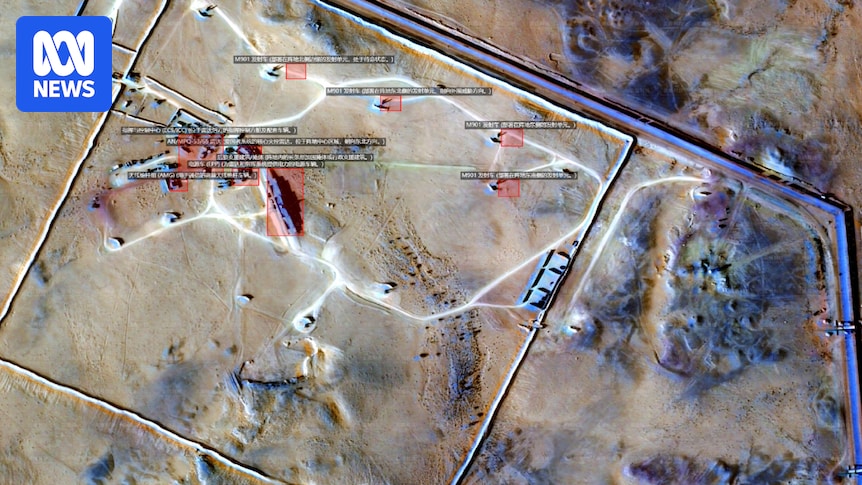
This technology identifies and tags military bases and other operations over vast areas.
Australian Defense Force retired Major General Gus McLachlan said the military needed to take into account Iran’s ability to potentially target areas as small as 0.3 square meters.
“We are witnessing targets, including U.S. E-3 Sentry aircraft, being hit with incredible precision. Our forces will take this threat very seriously, and rightly so,” he said.
“The Australian government will be concerned. It stands to reason that this capability could potentially kill Australians.
“This is a dangerous development because it would allow the Iranians to choose exactly what to target. Any object left in place 24 hours a day could become vulnerable to Iranian targeting cycles.”
About 100 Australian soldiers are stationed in the Middle East, including at facilities damaged in the March 18 attack by Iran in the United Arab Emirates.
Ryan Fedasiuk, a civil servant researcher at the U.S. State Department and a U.S. military analyst, said the AI-enhanced satellite imagery produced by MizarVision could allow the Iranian military to target U.S. forces and bases in near real time.
Reacting to the ABC article, he said: “Australian and American soldiers in the Middle East could be killed because of this. This is real-time battlefield information and it’s being used to harm American soldiers. It’s shocking.”
MizarVision uses this software to identify various military capabilities, including specific types of aircraft, the location of naval vessels, and the deployment of air defense systems across the Middle East.
Such capabilities once required the resources of national intelligence agencies.
Loading
Fedasiuk said that before the war, Iran did not have the ability to tag U.S. military assets in near real time.
“Iran does not have reliable access to satellite capabilities. This would give Iran that capability,” he said.
Fedasiuk has written papers on military uses of AI, including within the People’s Liberation Army.
According to the company list, Mizar Vision is a private company established in 2021 with a 5.5% stake from the government.
According to MizarVision’s website, the company’s mission is to “lower the barriers to geospatial intelligence discovery and analysis, making it no longer the exclusive competency of a few organizations.”
This image of Prince Sultan Air Base was released on February 25th. (Provided by: MizarVision)
Iran outsources military intelligence
Neither Fedasiuk nor Maj. Gen. MacLachlan have seen the classified DIA evaluation.
Reacting to the ABC report, Fedasiuk said Iran is effectively outsourcing to target data from Chinese companies.
“This is a further escalation in providing support quite directly to the Iranian military,” he said. “This is probably the largest Chinese support for a proxy force against the United States in this war.”
“This is an important development. The company has its sights set on the U.S. military, and this is valuable information for the Revolutionary Guard.”
China’s Ministry of Foreign Affairs said in a statement to the ABC that reports of Chinese companies supporting the Iranian military were “inflammatory.”
“The satellite imagery published by the companies involved was obtained through open source channels and is understood to be routine market practice,” he told the ABC.
The ministry said Chinese companies are required to “operate in accordance with laws and regulations” at all times.
Fedasiuk said AI capabilities were once limited to a few countries, and China has a responsibility to intervene.
“This is now in the public domain. China has an obligation to intervene and stop this,” he said.
“While there are legitimate questions to ask about the extent of Beijing’s support, and it is hard to believe that the Chinese government cannot control it, it is also possible that China does not realize the extent of the value this information provides to the Revolutionary Guards.” [Islamic Revolutionary Guard]. ”
Satellite providers run into trouble due to security risks
Satellite company Planet Labs announced over the weekend that the U.S. government has asked all satellite imagery providers to withhold images of conflict areas indefinitely.
A company spokesperson told the ABC before the announcement: “We have real concerns about the use of Planet data on Iran and the growing scope of risk in recent images.”
The restriction extends a 14-day delay in posting images of the Middle East that Planet Labs implemented last month.
The US-based company said the move was aimed at preventing adversaries from using the images to attack the US and its allies.
MizarVision did not respond to repeated requests for comment.
Major General McLachlan has a financial interest in Australian company DroneShield.


